Celestial Navigation Session #5
HISTORY:
The concept of analytical navigation using numbers, calculations and charting began in circa year 1300 and has been revised and expanded in capability ever since. Many practitioners and explorers documented and published new techniques and technologies as they were developed. The historical period known as "The Age of Discovery" was lead by Prince Henry, School of Navigation in around 1450. The plotting techniques, described in the "Line-of-Position" (LOP) navigation, and used in form CLS-98 were devised by Captain Thomas H. Sumner in 1837. Notably one of the greatest contributions was by Nathaniel Bowditch who published the "New American Practical Navigator in 1802, which has been revised and republished every few years still to this day.
TIME AND MERIDIAN DIAGRAMS
In stories 1 through 4 we learned to use the sextant, fill out the two forms and navigate by establishing a LOP, then determining our latitude and longitude. Oh, but there is a lot more to learn!
Two diagrams that aid in locating and understanding the motion of our celestial bodies are the time diagram, and the meridian diagram. It all begins with considering earth as a sphere and configuring triangles from the poles to our position and to our point of interest, either the stellar geographic position or travel destination. This celestial triangle is then analyzed using mathematics, and imagination.

Nathaniel Bowditch

In astronomy and navigation we must not ignore the importance, luxury and dependence on accuracy of time. Check, record and verify correct time prior to and after all telescopic and celestial navigation sights, and prepare the time diagram when needed.
The time diagram is printed on the upper middle of the SR-96a form. Imagine looking from the South Pole to the North Pole into the diagram. The ticks mark the hours on a 24-hour clock. M indicates your position and local time meridian, and m indicates the 12-hour position or antemeridian. Clockwise from M measure and mark your longitude. Mark this G, for Greenwich meridian. Opposite 12 hours from G mark g, the Greenwich antemeridian, and draw a line from G to g (dashed from center to g). The angle from M to G is the LHA of Greenwich. The time zones are counted counterclockwise from G in 15-degree increments centered at G, zero degrees longitude.


Measure and mark the position of GHA of the sun, moon or planet counterclockwise from G using data from the Nautical Almanac. The sun moves counterclockwise from G and passes M at noon in our zonetime, and m at our midnight, and our day advances. If the sun is between g and m, then it is a next day at G. To locate any other celestial body, measure and mark the GHA of Aries counterclockwise from G. Add to this angle counterclockwise the Sidereal Hour Angle (SHA), or 360° – RA, of a star or other body of interest. The angle between M and the body is the LHA of that body. By studying the time meridian angles the relationship of the relative positions of the bodies becomes apparent.

Imagine being in the west looking east into the meridian diagram. To the left is the northern horizon (N) and to the right the southern horizon (S). Above is your zenith (Z) and at the bottom is the Nader (Na). From the N and S line measure clockwise the angle of your latitude, and mark that as the North Pole (Pn) and South Pole (Ps). Draw a line from Pn to Ps. This represents the earth rotational axis. From Z and Na line measure clockwise your latitude and mark as Q above the horizon and Q’ below the horizon, representing the earth equator. Draw a line from Q to Q’ perpendicular to Pn-PS. To determine latitude in the northern hemisphere, measure from the horizon up to the star Polaris, or use your best DR estimate.
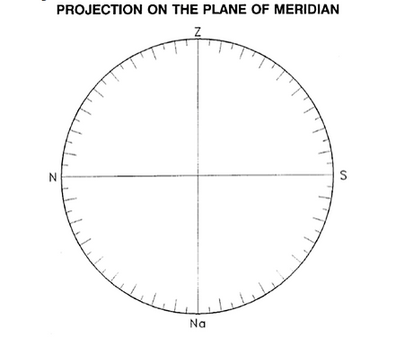
The next diagram of interest is more complex, but could be used to great advantage in navigation. This is the meridian diagram that is printed on the back of the SR-96a form.
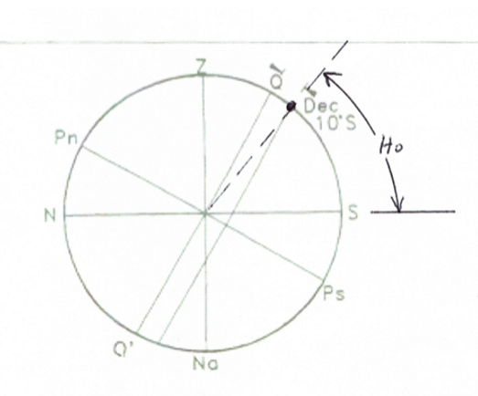
From the center of the diagram, measure and mark the angle of declination of a celestial body from Q counterclockwise if positive, and clockwise if negative. As the earth rotates about the axis line Pn to Ps the body moves parallel to Q - Q’. The body crosses the horizon N-S line rising in the east at sunrise and sets when the body crosses the N-S line in the west. When the body is due south of us, it is on the declination line on the outer circle at height Ho on our meridian diagram. Measure with a sextant the angle from the horizon up to the body, and this will be hs, or Ho when atmospheric corrections are accounted. Where the body crosses the N-S line indicates whether the body will rise north, or set south of our due east- west line. When the body crosses the vertical Z-Na (prime meridian) line it is due east or west. We are thinking in three dimensions here!
When a body is directly overhead at Z, then its’ declination is our latitude. When a body is not overhead but due south at maximum elevation, we could measure its’ height Ho and using its' declination and simple arithmetic determine our latitude from the diagram. When a body is due south at maximum Ho on our meridian LHA is zero, then its’ GHA is our longitude. Compare the time diagram and meridian diagram results with the data on form SR-96a to verify celestial navigation correctness. Using these Time and Meridian diagrams we can gain initial information on both navigation and astronomy. Our first premise is to learn to use numbers to support our skills with the telescope.

Using the basic trigonometry equations on form SR-96a, and a calculator, we could calculate Latitude and Longitude directly by using time, GHA, declination, and Ho, without the plotting task but you would have to be a better mathematician than me. That is what the GPS electronics do using received time differences from four or more satellites.
Again, when using the time and meridian diagrams for navigation, we are not lost!
There is more in the third dimension of these time and meridian diagrams that we could explore and analyze. However, that would require another story (actually a whole chapter). If you wish to learn more about celestial navigation, I encourage you to take the United States Power Squadron Navigation courses.
It is sad that the historical accomplishments and technologies used for navigation will all be lost and forgotten because of the invention and development of GPS and new electronics technologies. The old way of navigation is no longer being taught, except for us adventurous mariners and astronomers. How sad.....
I would like to have VCAS members interested in doing actual celestial navigation meet me at Ventura Harbor in September for an afternoon sun sight. If interested in participating, email our VCAS Outreach Coordinator, Gary Bustrup at vcasoutreach@gmail.com.
This concludes my sessions on Celestial Navigation. Thank you for letting me write and include these short stories on the VCAS website. I hope you enjoyed and learned from them.

End of Session Five

