Introduction to Celestial Navigation
How to Point a Telescope and Navigate Using Numbers
By David Williams
Excepts courtesy of the:
United States Power Squadron Navigation Texts
Starpath Texts
Uncle Al's Texts
Goggle Sources
When we travel it is wonderful if we can take our telescope with us, and we really should. Once there, wherever our destination it would be really nice if we new exactly where to look to see and marvel at our sky and its treasurers. Most amateur astronomers know how to find a constellation and then star hop to our treasure. This can be tedious and take much of our time. Wouldn't it be nice if we knew the coordinates of our treasure, have a setting device on our telescope to just align the scope and look into the eyepiece and there it would be? Some of the amateurs have automatic electronic packages now to do just that. But those fancy mounts are really not necessary and can cost a lot of money. There is a way to calculate the alignment coordinators.
In this series of short stories we will explain how to do that. It is not hard, or even difficult. With just a few relatively simple calculations we can have all that is necessary to point the telescope. We do not have to be mathematicians or use computer programs. We just need to have a few reference tables and a procedure to follow. Navigators and astronomers have been doing this for hundreds of years. Let us not forget how to do it as new technologies take over our thought and mind. Memories of the old ways are easily lost, as manufacturers have encouraged through marketing of their products. There are plenty of reference texts in libraries and many old folks, like me, that can teach us. So follow me through this series of short stories and we shall learn to do it.
Session #1
Navigators and astronomers alike use the stars for pleasure and navigation. Navigators use the stars to find their location and plan a path to the next destination. Astronomers use the stars for pleasure and to explore the universe. Wherever we are, the sky and its treasures may be in a different location. That is the star coordinates may have different values depending on our location and time. For astronomers, the most important task is to know how to point the telescope and record their findings so they can tell others how to find the celestial body and also enjoy the view. Navigators use the stars to find their location on the sea or anywhere else they may explore.


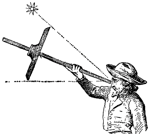
Both navigators and astronomers have known for millennia how to use the stars, planets, sun, and moon for both tasks. The astrolabe has been perfected in ancient times as a tool to do just that. The astrolabe is suspended from the top ring and the alidade, or center rotating cross bar, points to the star and measure its height above the horizon. Central rings were then used to locate important constellations or points of interest.
Many other instruments like the Kamal (a stick on a string) and cross staff were devised to improve the measuring accuracy. The cross staff after the 15th century and with improvements were used by the world explorers to navigate the seas. With accurate measurements of the star heights above the horizon the location of the observer and the description of lands they were exploring could be recorded and then the information passed on to others for their use.
The most important improvement is the knowledge of the use of numbers to express the information in a usable printable form. This is the end objective of this story.
Simply put:
"I often say that when you can measure what you are speaking about and express it in numbers, you know something about it; but when you cannot express it in numbers, your knowledge is of a meager and unsatisfactory kind; it may be the beginning of knowledge, but you have scarcely, in your thoughts, advanced to the stage of Science, whatever the matter may be."
Lord Kelvin (1824-1907)
Navigators and astronomers each created star charts and tables with this data to aid in location of the stars, constellations, and celestial bodies of interest. The planisphere became a tool to learn the heavens. On this the constellations and navigation stars are identified as they were on the astrolabe. This example in the image below shows a modification of the one taken from Uncle Al's Star Wheels, (www.lawrencehallofscience.org/starclock/skywheel.html) with the recognized navigation stars marked in red.
Astronomers and navigators each use the same science and knowledge of the heavens to accomplish different tasks. The navigator uses the stars marked in red to find location and plan a course. The astronomer may use these stars to point the telescope and record observations. The concept of time and celestial body coordinates is the same for both tasks. They just are used for a different application.


The discussion that follows enables the navigator or astronomer to easily prepare the telescope mount or sextant to use the star coordinates to point the telescope, or to find position. Consider the sextant to be a less fancy astrolabe with a telescope attached.
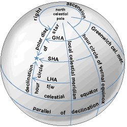
But first, let us review the definitions in the measurement system. On Earth, a sphere referenced to its center, Latitude is the angular distance from the equator, 0 degrees, to the North Pole, +90 degrees, and to the South Pole, -90 degrees. The local meridian is an arc from North Pole through our position, perpendicular to the equator, to the South Pole. Our position, (parallels latitude), is the angular distance from the equator to where we are on our meridian. The Longitude is measured in degrees from the meridian of Greenwich England to any other meridian, 0 degrees westward to +180 degrees or 0 degrees eastward to -180 degrees. Time is measured from the Greenwich meridian following the mean sun westward; at one hour increments marked every 15 degrees of longitude 0 to 24 hours. Most folks now have a GPS unit in their pocket to determine their local position latitude and longitude coordinates and Greenwich Mean Time, or they can use a good chart for scale and local time on a clock.
Celestial navigators and astronomers project the latitude- longitude grid outward onto the celestial sphere and give them new names to position the celestial bodies. Latitude becomes declination and is measured from the celestial equator north or south 0 to + or - 90 degrees. Since the earth rotates with respect to the stars, the celestial sphere passes westward as viewed from our local meridian, so a new 0 degree reference is chosen. The meridian at which the sun crosses the celestial equator northward in the spring is chosen, and is called the First Point of Aries 0 degrees Sidereal Hour Angle (SHA). All bodies SHA position is measured westward from this meridian. Their celestial coordinates SHA and declination thus identify all celestial bodies on the celestial sphere. We then must determine where Aries is.
To compensate for the Earth's rotation (time) navigators and astronomers want to locate Aries and then the meridian of the celestial body of interest. They must calculate the Local Hour Angle (LHA) meridian of the body. The LHA is measured from their local meridian westward 0 degrees to 360 degrees as a function of time. The method of calculation of LHA will be shown later.
Astronomers use a time coordinate called Right Ascension, (RA) which is the time since the passing of the meridian of Aries measured eastward to the body opposite to SHA. A mean solar day is a complete earth rotation relative to the sun. A sidereal day is a complete rotation of the earth relative to the First Point of Aries. Since there are 24 hours of time in a day, there are 24 hours of RA in a celestial day. But the duration of a celestial day is measured relative to the stars in sidereal time, which is about 4 minutes shorter than mean solar time in a day. RA = (360° - SHA°) converted to time units. A simple time diagram can be drawn to clarify this relationship.
The sun moves about one degree eastward daily or the stars move one degree westward daily. Our local meridian passes Aries and then the sun with 4 minutes difference daily. Specially designed clocks in the observatory show this sidereal time. With sidereal time the astronomers learn which bodies are up at any particular time indicated on the sidereal clock. However, amateur astronomers do not have a sidereal clock handy, though one could easily be made. The disadvantage of sidereal time is that time units cannot be used in trigonometry equations which use units of degrees. All these measurement coordinates may seem complex, but with practice they are easily understood.
Only three coordinates: the observer’s latitude, the bodies’ declination, and LHA, determine the location of any celestial body from our local meridian. From only these three coordinates the observer can point the telescope or sextant. By measuring the height of the body above the horizon the navigator can calculate his true position latitude and longitude, including direction and height to the body. Each of these coordinates is a number, in degrees, which can be recorded and told to the rest of us.
In the next months stories we will discuss the methods for determining these coordinates and to either point the telescope or actually doing the celestial navigation. Wouldn't it be wonderful if we presented our treasure findings at the next VCAS meeting?
End of Session One

